.jpg)
Garmin GPSMAP® 60CSx: Is this the ultimate handheld?
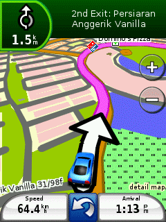
If you primarily use a handheld GPS receiver in the outdoors but occasionally use it in the car, this is the receiver to own. The GPSMAP 60CSx has all the features of a high-end outdoor handheld, plus those found in a car navigation system to boot. The only hitch for auto use is that the screen size makes it hard to see both the screen and the road, so have the passenger navigate.
When I first picked up the GPSMAP 60CSx and began scrolling through the menus, I was struck by how many features it has. This receiver has everything. In fact it is probably easier to list the features it does not have because the list would be virtually empty. The GPSMAP 60CSx is what I would consider the ultimate machine of handhelds.

The key to this receiver is deep in the machine. A microchip, the brains of this receiver, provides the bulk of its features. The microchip is supplied by SiRF, a company that specializes in advanced GPS technology. It provides high sensitivity to detect satellite signals even in urban canyons, enables fast start-up, and connects with the thousands of points-of-interest stored in the unit’s database.
Like other high-end handheld receivers, the GPSMAP 60CSx has an electronic compass and a barometric altimeter. It stores 1,000 waypoints, 50 reversible routes, 10,000 tracking points, and 20 saved tracks. It accepts MicroSD cards with detailed maps, has a colored screen . . . the list just keeps going.
The GPSMAP 60CSx has automatic routing capability so that the route to a destination can follow the roads in the receiver’s electronic maps. This feature, usually found only in car navigation systems, makes the GPSMAP 60CSx useful for road travel. However, this usefulness is limited by the small screen size. It is next to impossible for the driver to see the screen while the receiver is positioned on the dash to pick up the satellites. And even though the GPSMAP 60CSx provides a turn-by-turn list of directions to alert the user when the next turn is approaching, it does not talk to you like some car systems. One solution is to let a passenger use the receiver while being the navigator.
The GPSMAP 60CSx also provides an extensive list of points-of-interest (POI). Granted, the POI are not related to the wilderness, so it is another feature associated with roads and cities, but if you are returning from the wilderness and need to get to gas, food, a hotel, or even a museum, you will be able to find the nearest “whatever” using your receiver.
An interesting feature, that as of yet I have not seen on any other device, is the ability to set the page sequence. Pressing the “page” button tells the receiver to show a different screen. You can either add or subtract screens that are shown by pressing the “page” button. If you have only a few favorites, you can save button presses to cycle between them. Almost any screen can be added to the page sequence list.

The microSD card is placed in a slot in the battery compartment. Cards may be purchased with preloaded maps or data may be transferred to a card via a serial or USB connection.
The GPSMAP 60CSx also has a feature called the Jumpmaster for skydivers. Although I do not skydive, the feature seems really useful. It calculates a high-altitude release point (HARP) and guides you to a desired impact point (DIP). It provides options for high-altitude high opening (HAHO), high-altitude low opening (HALO), and static jumping. For those inclined to jump, the GPSMAP 60CSx seems like a fun tool.
Overall the GPSMAP 60CSx is a dream receiver: Powerful, compact, and light weight, with tons of features.
Key specifications:
Display: (WxH) 1.5" x 2.2" (3.8 x 5.6 cm)
Size: (WxHxD) 2.4" x 6.1" x 1.3" (6.1 x 15.5 x 3.3 cm)
Weight: 7.5 ounces (213g) with batteries
Battery: 2 AA batteries; 18 hours typical
Data storage: 64 MB microSD card
Environmental: Rated waterproof to IPX-7 standards